Quick Answer
A 4 MW commercial rooftop project in Stuttgart. It is how the best solar companies operate in 2026. Industry standard. 5-return LiDAR, 4 cm accuracy, 250 m range DJI Mavic 3 Enterprise (Thermal). Dual visible/thermal camera; best value for residential FAA Part 107 Remote ID.
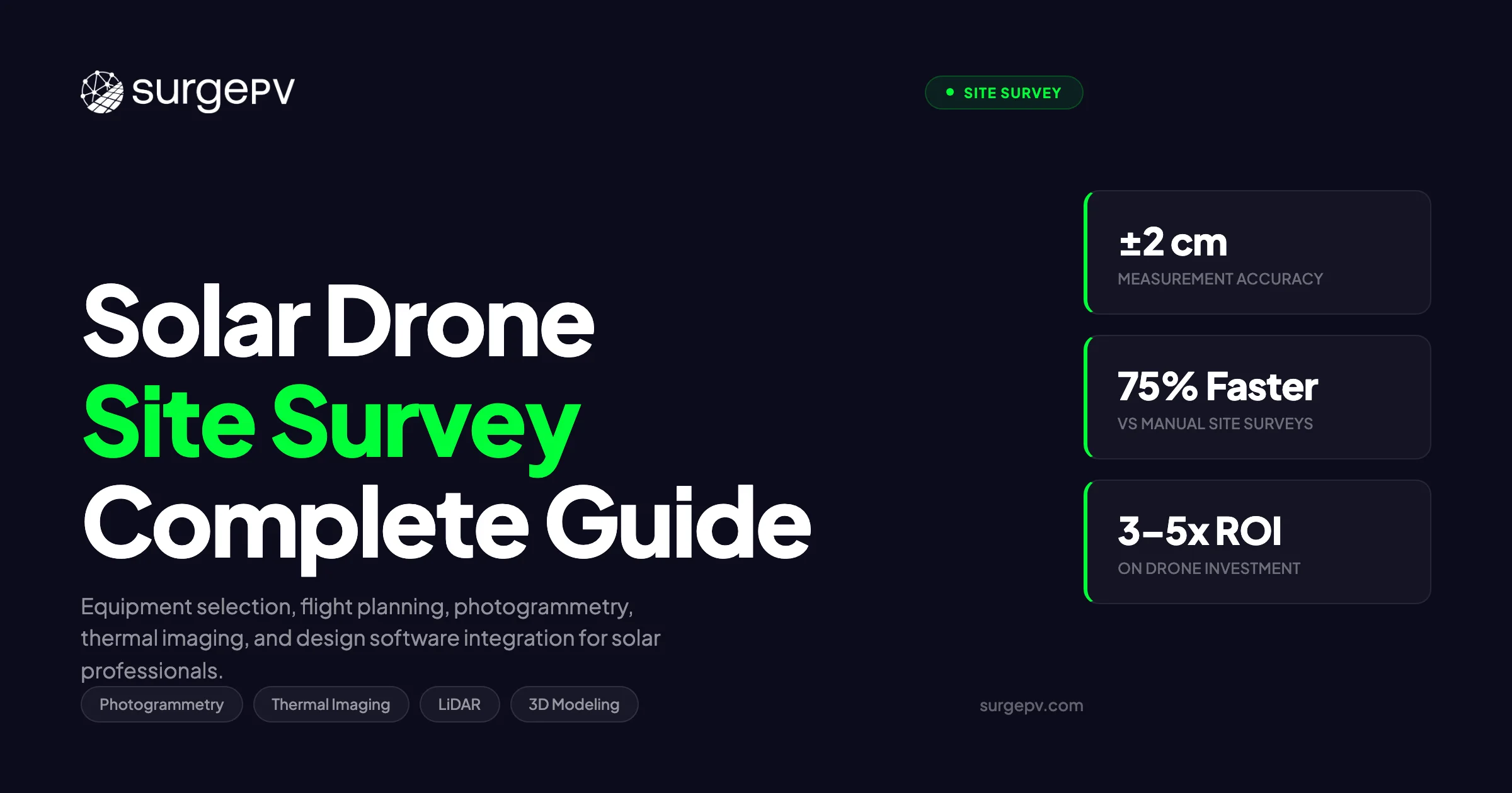
A 4 MW commercial rooftop project in Stuttgart. The roof is a multi-level industrial complex with HVAC units, skylights, and parapet walls at varying heights. A crew with tape measures and inclinometers would need two full days on-site, plus the liability of working at height. A DJI Matrice 350 RTK with a LiDAR payload completes the same survey in 28 minutes, produces a 3D point cloud accurate to 1.5 cm, and the pilot never sets foot on the roof.
A 4 MW commercial rooftop project in Stuttgart. It is how the best solar companies operate in 2026. Industry standard. 5-return LiDAR, 4 cm accuracy, 250 m range DJI Mavic 3 Enterprise (Thermal). Dual visible/thermal camera; best value for residential FAA Part 107 Remote ID.
That scenario is no longer exceptional. It is how the best solar companies operate in 2026. Drone-based site surveys have moved from novelty to standard practice for any installer handling more than a dozen projects per month. The economics are straightforward: faster data capture, better accuracy, lower safety risk, and a direct data pipeline into solar design software.
This guide covers everything you need to run drone surveys for solar projects, whether you are building an in-house capability or evaluating outsourced services.
TL;DR — Solar Drone Site Surveys 2026
Drone surveys deliver 1-5 cm accuracy for solar site assessment, cut survey time by 60-80% versus manual methods, and feed directly into design software for panel layout and shade analysis. Equipment costs start at $4,500 for a capable enterprise drone. FAA Part 107 certification is required in the US; EU operators need EASA Specific category authorization. Photogrammetry handles most residential and commercial projects. LiDAR is the standard for utility-scale and complex rooftops. Thermal imaging adds value for O&M inspection of existing arrays.
In this guide:
- Latest 2026 updates in drone technology and regulations for solar surveys
- Why drone surveys are replacing tape-measure site assessments
- Types of drone data: photogrammetry, thermal IR, LiDAR, and multispectral
- Equipment comparison table: top drones for solar site work
- Step-by-step survey workflow from flight planning to design software import
- Photogrammetry processing: from images to 3D models
- Thermal imaging for defect detection on existing installations
- FAA Part 107, EU EASA rules, and BVLOS waivers
- Cost analysis: drone survey vs. traditional methods
- When to use drone data vs. satellite imagery
- Integrating drone deliverables with solar design software
- Common mistakes and how to avoid them
Latest Updates: Solar Drone Surveys 2026
The drone survey market for solar moved fast between 2024 and early 2026. Hardware improved, regulations loosened in specific areas, and software integration became more seamless. Here is the current status of the major developments.
Solar Drone Survey Industry Status — March 2026
| Development | Status | Detail |
|---|---|---|
| DJI Matrice 350 RTK + Zenmuse L2 | Industry standard | 5-return LiDAR, 4 cm accuracy, 250 m range |
| DJI Mavic 3 Enterprise (Thermal) | Widely adopted | Dual visible/thermal camera; best value for residential |
| FAA Part 107 Remote ID | Mandatory (March 2024) | All commercial drones must broadcast Remote ID |
| FAA BVLOS waiver expansion | In progress | ASTM F3322 standard adopted; site-specific BVLOS waivers growing |
| EU EASA Specific category | In force | Operational authorization required for most solar survey flights |
| EU U-space airspace management | Phased rollout | U1/U2 services live in select EU member states |
| Automated flight planning (DJI Pilot 2, Litchi, DroneDeploy) | Mature | Terrain-following, overlap control, and waypoint precision standard |
| Cloud photogrammetry (DroneDeploy, PIX4D, OpenDroneMap) | Mature | Sub-hour processing for residential sites; same-day for commercial |
| Direct DSM import to solar design tools | Growing | GeoTIFF and LAS import supported by leading platforms |
| AI-powered thermal defect detection | Early adoption | Automated hotspot classification accuracy reaching 90%+ |
Key Changes Since 2024
Remote ID is now mandatory. Since March 2024, every drone used for commercial operations in the US must broadcast Remote Identification data. If you are flying an older drone without built-in Remote ID, you need an add-on broadcast module. Non-compliance carries fines up to $27,500 per violation.
LiDAR costs dropped significantly. The DJI Zenmuse L2, released in late 2023, brought survey-grade LiDAR to a price point under $5,000 for the payload alone. Before this, comparable LiDAR sensors cost $15,000-40,000. This single price reduction made LiDAR viable for routine commercial solar surveys, not just utility-scale projects.
BVLOS operations expanding. The FAA adopted the ASTM F3322 standard for beyond-visual-line-of-sight operations. While blanket BVLOS authorization for all operators remains pending, site-specific waivers are being granted more frequently. For solar, this matters most for large ground-mount surveys where maintaining visual contact limits efficiency.
Pro Tip
If you purchased a DJI Matrice 300 RTK before 2024, check your Remote ID compliance status. The M300 received a firmware update enabling Remote ID broadcast, but it requires manual activation. Flying without it active is a federal violation regardless of your Part 107 status.
Why Drone Surveys Are Replacing Manual Site Assessment
Manual solar site surveys work. Installers have used tape measures, inclinometers, Suunto clinometers, and SunEye shade analyzers for decades. The results are acceptable for simple residential rooftops. But as project complexity increases, the limitations of manual methods compound.
The Core Problem with Manual Surveys
A manual residential roof survey takes 45-90 minutes on-site. The surveyor measures roof dimensions, identifies obstructions, estimates shading from nearby trees and structures, checks roof pitch with an inclinometer, and photographs everything. Back in the office, someone translates those measurements into a solar panel layout.
The weak links in this process are measurement accuracy and shade assessment. A tape measure on a pitched roof yields measurements accurate to roughly 5-15 cm. That is adequate for most residential panel layouts. But shade assessment with a handheld tool captures conditions at a single point in time, from a single position. It does not account for the full annual sun path across every square meter of the roof.
A drone survey captures the entire roof geometry and surrounding environment in a single flight. The output is a 3D model that solar shadow analysis software can use to simulate shading across every hour of the year, at every point on the surface.
Speed Comparison
| Project Type | Manual Survey Time | Drone Survey Time | Time Savings |
|---|---|---|---|
| Residential rooftop (single-family) | 45-90 min on-site + 30 min office | 15-20 min flight + 20 min processing | 50-65% |
| Commercial rooftop (10,000 sq ft) | 3-6 hours on-site + 2 hours office | 25-40 min flight + 1-2 hours processing | 60-75% |
| Multi-building commercial complex | 1-2 days on-site + 4-8 hours office | 1-2 hours flight + 3-6 hours processing | 70-80% |
| Utility-scale ground mount (50 acres) | 3-5 days survey crew | 2-4 hours flight + 1-2 days processing | 75-85% |
Safety Advantage
This is not a marginal benefit. Falls from roofs account for a significant share of construction industry fatalities. A drone survey eliminates roof access entirely for the initial assessment. The surveyor stays on the ground. For commercial projects with flat roofs, parapet walls, and HVAC equipment, this removes a genuine liability risk.
OSHA data shows that falls remain the leading cause of death in construction, accounting for roughly one-third of all fatalities annually. Every roof access event carries risk. A drone survey for the initial assessment means the first time anyone steps on the roof is during installation, with proper fall protection in place per solar safety compliance requirements.
Accuracy Advantage
Manual measurements introduce human error. Tapes sag. Inclinometers are read at angles. Obstructions behind the surveyor are missed. Drone photogrammetry with ground control points delivers 2-5 cm accuracy across the entire site. RTK-equipped drones achieve 1-3 cm without ground control.
That accuracy matters most for commercial and utility-scale projects where cumulative measurement error across a large area translates directly into miscounted panel positions, incorrect string layouts, and inaccurate energy yield predictions.
Key Takeaway
Drone surveys are not just faster. They produce fundamentally better data: complete 3D geometry of the site and surroundings rather than point measurements and photographs. This complete dataset feeds directly into design software for accurate shade simulation and optimized panel placement.
Types of Drone Data for Solar Projects
Not every solar project needs the same type of drone data. The four primary sensor categories each serve distinct purposes. Choosing the right one, or the right combination, depends on whether you are surveying a new site or inspecting an existing installation.
1. RGB Photogrammetry
What it captures: High-resolution visible-light photographs from multiple overlapping angles.
What it produces: Orthomosaics (geometrically corrected aerial images), digital surface models (DSMs), 3D point clouds, and textured mesh models.
Solar applications:
- Roof geometry measurement (area, pitch, orientation)
- Obstruction identification and measurement (vents, chimneys, HVAC, skylights)
- Tree and building shade source mapping
- Site documentation for permit applications
- Input data for solar design platform panel layout tools
Accuracy: 2-5 cm with ground control points; 1-3 cm with RTK
Best for: New site assessment for residential and commercial rooftop projects. This is the workhorse data type for solar surveys. Most residential projects need nothing beyond good photogrammetry.
2. Thermal Infrared (IR) Imaging
What it captures: Radiometric thermal data in the 8-14 micrometer wavelength range, measuring surface temperature at each pixel. For Italy-specific information, see [Commercial Rooftop Solar Case Study Italy](/blog/commercial-solar-rooftop-case-study-italy-warehouse).
What it produces: Thermal orthomosaics showing temperature distribution across solar panels or roof surfaces.
Solar applications:
- Hotspot detection on existing PV arrays (cell defects, bypass diode failures, junction box issues)
- Substring and string-level fault identification
- Soiling and debris impact assessment
- Pre-installation thermal profiling of roof surfaces
- Inverter and combiner box thermal inspection
Accuracy: Temperature measurement accuracy of +/- 2-5 degrees C at typical flight altitudes; spatial resolution dependent on sensor and altitude
Best for: O&M inspection of existing solar installations. For new site surveys, thermal data is secondary. For fleet operators managing hundreds or thousands of panels, thermal drone inspection is now the primary defect detection method. Also see: Us Residential Solar Market Trends 2026.
3. LiDAR (Light Detection and Ranging)
What it captures: Laser pulses that measure distance to surfaces, generating millions of 3D coordinate points per second.
What it produces: Dense 3D point clouds with precise elevation data. Can penetrate vegetation canopy to map ground surface below.
Solar applications:
- High-accuracy roof and terrain elevation models
- Vegetation canopy height measurement for shade analysis
- Ground-mount terrain mapping including slopes and grading requirements
- Transmission line and interconnection infrastructure surveying
- Utility-scale site feasibility including drainage and access road planning
Accuracy: 1-2 cm vertical accuracy at typical flight altitudes (40-80 m AGL)
Best for: Utility-scale ground-mount projects, complex commercial rooftops, and any site where vegetation canopy needs to be penetrated. LiDAR excels where photogrammetry struggles: dense tree cover, featureless terrain (bare soil), and situations requiring precise vertical measurements.
4. Multispectral Imaging
What it captures: Reflected light across multiple narrow spectral bands (typically red, green, blue, red edge, and near-infrared).
What it produces: Vegetation health indices (NDVI), spectral reflectance maps.
Solar applications:
- Vegetation growth assessment around ground-mount arrays
- Agricultural land use mapping for agrivoltaic projects
- Panel surface reflectance analysis (research applications)
Best for: Agrivoltaic installations and environmental impact assessment. This is a niche data type for solar, relevant primarily to utility-scale projects that combine solar generation with agricultural land use.
Sensor Selection Guide
| Project Type | Primary Sensor | Secondary Sensor | Notes |
|---|---|---|---|
| Residential rooftop (new) | RGB photogrammetry | None needed | Mavic 3 Enterprise is sufficient |
| Commercial rooftop (new) | RGB photogrammetry | LiDAR if complex | Add LiDAR for multi-level roofs with dense obstructions |
| Utility-scale ground mount (new) | LiDAR | RGB photogrammetry | LiDAR for terrain; RGB for site documentation |
| Existing array inspection | Thermal IR | RGB photogrammetry | Thermal for defects; RGB for visual documentation |
| Agrivoltaic assessment | Multispectral | RGB photogrammetry | NDVI for crop health monitoring |
Drone Equipment for Solar Surveys
The drone market consolidates around a few platforms that have become standards for solar survey work. This table compares the most commonly used systems in 2026.
Top Drones for Solar Site Surveys — 2026
| Drone | Camera / Sensor | Flight Time | RTK | Weight | Price (USD) | Best For |
|---|---|---|---|---|---|---|
| DJI Matrice 350 RTK | Swappable: Zenmuse P1 (photogrammetry), L2 (LiDAR), H20T (thermal) | 55 min (no payload) | Yes (built-in) | 6.47 kg (body) | $11,000 (body) + $5,000-9,000 (payload) | Commercial & utility-scale |
| DJI Mavic 3 Enterprise (Thermal) | 4/3 CMOS 20MP + 640x512 thermal | 45 min | Optional (RTK module) | 920 g | $4,500-5,200 | Residential & small commercial |
| DJI Mavic 3 Enterprise (CMOS) | 4/3 CMOS 20MP wide + 162mm tele | 45 min | Optional (RTK module) | 915 g | $3,500-4,000 | Residential photogrammetry |
| Autel EVO II Pro V3 | 1-inch CMOS 20MP, 6K video | 42 min | Yes (optional RTK kit) | 1.19 kg | $2,500-3,500 | Budget residential/commercial |
| Autel EVO Max 4T | Triple camera (wide, zoom, thermal) + LiDAR rangefinder | 42 min | Yes (built-in) | 1.16 kg | $7,500-8,500 | Multi-sensor commercial |
| senseFly eBee X (AgEagle) | Swappable: S.O.D.A. 3D, Aeria X, ThermoMAP | 90 min | Yes (PPK) | 1.6 kg | $15,000-25,000 (with sensor) | Large-area mapping, utility-scale |
| Wingtra WingtraOne GEN II | 42 MP full-frame or LiDAR | 59 min | Yes (PPK/RTK) | 4.4 kg | $25,000-35,000 | Utility-scale terrain mapping |
| Freefly Astro | Sony Alpha payload | 30 min | Optional | 4.0 kg | $12,000+ | High-res photogrammetry |
Choosing the Right Platform
For residential solar companies doing 10-50 surveys per month: The DJI Mavic 3 Enterprise is the default choice. It is portable enough to carry between jobs, the 45-minute flight time covers any residential site with margin, and the image quality produces clean photogrammetry. The thermal variant adds defect inspection capability for existing installations. Total investment: $4,500-5,200 plus $500-1,000 for spare batteries and accessories.
For commercial installers and EPCs: The DJI Matrice 350 RTK with interchangeable payloads is the workhorse. Start with the Zenmuse P1 for photogrammetry. Add the L2 LiDAR when projects justify it. The built-in RTK means centimeter-level positioning without ground control points, which saves 30-45 minutes of GCP setup per site. Total investment: $16,000-20,000 for body plus one payload.
For utility-scale developers: Fixed-wing drones like the senseFly eBee X or WingtraOne cover large areas far more efficiently than multirotors. A fixed-wing can map 50 acres in a single flight. A multirotor would need multiple battery swaps. The tradeoff is landing precision and the inability to hover for detailed inspection of specific features.
Pro Tip
Do not buy a LiDAR payload until you have a pipeline of projects that justify it. Start with RGB photogrammetry. A Mavic 3 Enterprise with proper flight planning and ground control points delivers 2-3 cm accuracy, which is more than sufficient for residential and most commercial rooftop solar designs. LiDAR becomes cost-justified at roughly 3-5 commercial projects per month or any utility-scale work.
The Solar Drone Survey Workflow
A complete solar drone survey follows a six-step process. Each step has specific requirements and outputs that feed the next.
Step 1: Pre-Flight Planning
Before any drone leaves the ground, you need three things: airspace authorization, a flight plan, and weather clearance.
Airspace check. In the US, use the FAA’s LAANC system (Low Altitude Authorization and Notification Capability) for automated airspace authorization. LAANC provides near-instant approval for flights in controlled airspace below pre-approved ceiling altitudes. For uncontrolled airspace (Class G), no authorization is needed under Part 107, but you still must check for NOTAMs and TFRs.
Flight plan. Use mission planning software (DJI Pilot 2, Litchi, DroneDeploy, Pix4Dcapture) to define:
- Flight altitude: 40-60 m AGL for residential photogrammetry; 60-80 m for commercial; 80-120 m for utility-scale
- Front overlap: 75-80% minimum for photogrammetry
- Side overlap: 65-75% minimum
- Camera angle: nadir (straight down) for DSM generation; 45-degree oblique passes for 3D mesh
- Ground sampling distance (GSD): target 1-2 cm/pixel for residential; 2-5 cm/pixel for utility
Weather window. Optimal conditions for solar site photogrammetry: overcast sky (reduces harsh shadows in imagery), wind below 20 km/h, no precipitation, temperature above 0 degrees C (battery performance degrades in cold). For thermal surveys, fly within 2 hours of solar noon with clear skies to maximize thermal contrast.
Step 2: Ground Control Points (If Not Using RTK)
If your drone lacks RTK positioning, place 4-8 ground control points (GCPs) around the survey area before flying. GCPs are physical markers (typically checkerboard pattern targets, 30x30 cm minimum) surveyed with a GNSS receiver to centimeter accuracy. They anchor the photogrammetry model to real-world coordinates.
GCP placement rules:
- Minimum 4 GCPs for any survey; 6-8 for sites larger than 0.5 acres
- Distribute evenly across the survey area, including corners
- At least one GCP at highest and lowest elevation points
- Survey each GCP position with RTK GNSS for 60+ seconds
RTK-equipped drones skip this step entirely. The drone records centimeter-accurate coordinates for each image at capture time. This eliminates 30-45 minutes of GCP setup and survey.
Step 3: Data Capture
Execute the mission plan. For a standard photogrammetry survey of a residential roof:
- Nadir pass: Fly the automated grid pattern at planned altitude with 80% front overlap and 70% side overlap. This captures the primary data for orthomosaic and DSM generation.
- Oblique pass (optional but recommended): Fly a second pattern at 45-degree camera angle around the building perimeter. This captures wall-mounted obstructions, roof edges, and vertical features that nadir-only imagery misses.
- Detail captures: Manual flyover of specific features: complex roof intersections, nearby shade-casting trees, electrical service entry point, proposed inverter mounting location. Read Solar Racking Design Guide for a complete walkthrough.
For thermal surveys of existing arrays, the process differs:
- Fly at 15-25 m altitude for adequate thermal resolution (each pixel covering 3-5 cm of panel surface)
- Maintain consistent altitude throughout, as thermal pixel size varies directly with height
- Time the flight for peak irradiance, with arrays producing at least 600 W/m2
Step 4: Photogrammetry Processing
Transfer imagery to processing software. The three dominant platforms for solar survey photogrammetry:
| Software | Processing Location | Typical Processing Time (Residential) | Output Formats | Price |
|---|---|---|---|---|
| DroneDeploy | Cloud | 30-60 min | GeoTIFF, OBJ, LAS, orthomosaic | $329-499/month |
| Pix4Dmapper | Desktop or cloud | 45-120 min | GeoTIFF, LAS, OBJ, PLY | $350/month or $4,990 perpetual |
| OpenDroneMap (WebODM) | Desktop (self-hosted) | 60-180 min | GeoTIFF, LAS, OBJ | Free (open source) |
| Agisoft Metashape | Desktop | 60-180 min | GeoTIFF, LAS, OBJ, PLY | $179 (Standard) / $3,499 (Pro) |
The processing pipeline: image alignment (structure from motion) creates a sparse point cloud, then dense matching generates a dense point cloud, then surface reconstruction creates a mesh, and finally the software generates the orthomosaic and DSM.
Step 5: Quality Check and Deliverable Generation
Before importing into design software, verify the processed data:
- Accuracy check: Compare DSM elevations at GCP locations to known values. RMS error should be under 5 cm for solar design purposes.
- Completeness: Check the orthomosaic for gaps, blurred areas, or stitching artifacts. Common problem areas: reflective surfaces (glass skylights, metal roofing), shadowed zones, and areas with poor overlap.
- Export deliverables: Orthomosaic as GeoTIFF, DSM as GeoTIFF, 3D point cloud as LAS/LAZ, and optional textured mesh as OBJ.
Step 6: Import to Solar Design Software
The final step is bringing drone data into the design tool. This is where the survey data becomes a solar panel layout.
Most modern cloud solar design tool platforms accept GeoTIFF orthomosaics as base imagery layers and DSM/point cloud data for 3D terrain modeling. The drone-derived DSM replaces lower-resolution satellite elevation data, giving the design tool accurate roof geometry for:
- Panel placement with precise dimensions
- Shadow analysis using actual measured obstruction heights
- Tilt and azimuth measurement from the DSM surface normals
- Setback compliance calculation from measured roof edge positions
Platforms like Scanifly specialize in connecting drone capture directly to solar design. See our Scanifly review for a detailed assessment of their workflow.
Pro Tip
Process your drone data at the highest quality setting even if it takes longer. Downsampling a high-quality DSM for design software import is easy. Recovering detail lost to low-quality processing requires re-flying the site.
Photogrammetry for Solar: From Images to 3D Models
Photogrammetry is the core technology behind most drone-based solar surveys. Understanding how it works helps you capture better data and troubleshoot processing problems.
How Structure from Motion Works
Structure from motion (SfM) is the algorithm that converts overlapping 2D photographs into 3D geometry. The software identifies matching features (corners, edges, texture patterns) across multiple images taken from different positions. By triangulating these feature matches using the known camera positions, it calculates the 3D coordinates of each point.
The quality of the output depends entirely on the quality of the input. Three factors dominate:
Overlap. More overlap means more feature matches per point, which means higher accuracy. For solar surveys, 75-80% front overlap and 65-70% side overlap is the minimum. Increasing to 85% front and 75% side adds flight time but measurably improves accuracy on complex roofs.
Ground sampling distance. GSD is the real-world size of one pixel. At 40 m altitude with a 20 MP sensor, GSD is approximately 1.0-1.5 cm. At 80 m, it doubles to 2.0-3.0 cm. For residential solar where you need to identify individual vents and pipe penetrations, keep GSD under 2 cm.
Lighting conditions. Overcast skies produce the best photogrammetry results. Harsh shadows create sharp tonal transitions that confuse feature matching algorithms. They also hide detail in shadowed areas. If you must fly in direct sun, fly when the sun is high (within 2 hours of solar noon) to minimize shadow length.
Common Photogrammetry Failures in Solar Surveys
| Problem | Cause | Fix |
|---|---|---|
| Holes in the point cloud over roof sections | Insufficient overlap on sloped surface | Increase overlap to 85%+ or add oblique passes |
| Domed or warped DSM | No ground control points and poor GPS | Add GCPs or use RTK drone |
| Blurred orthomosaic sections | Drone moving too fast for shutter speed | Reduce flight speed or increase shutter speed |
| Missing roof edges | Nadir-only capture misses vertical faces | Add 45-degree oblique perimeter pass |
| Noisy DSM over glass skylights | Specular reflection confuses matching | Mark and interpolate these areas in post-processing |
| Incorrect scale | GCPs not accurately surveyed | Re-survey GCPs with calibrated GNSS equipment |
From DSM to Solar Design Input
The digital surface model is the primary deliverable that solar design software consumes. A DSM represents the elevation of everything visible from above: the roof surface, HVAC units on the roof, trees, adjacent buildings. It does not represent bare ground (that is a digital terrain model, or DTM).
For solar design, the DSM gives you:
- Roof plane extraction: The software identifies planar surfaces in the DSM and calculates their tilt, azimuth, and area. These become the available mounting zones for panels.
- Obstruction heights: HVAC units, vents, and skylights appear as elevated features on the DSM. Their heights above the roof plane determine shadow casting distance and setback requirements.
- Shade source mapping: Trees, adjacent buildings, and other structures in the DSM cast computed shadows based on their height and position relative to the array area. This is the input for annual shading analysis.
The accuracy of shade analysis is directly proportional to the accuracy of the DSM. A 2 cm accurate DSM produces shade maps that match reality. A DSM derived from satellite imagery, with 1-3 m accuracy, produces shade estimates with significant uncertainty, particularly for near-field obstructions like roof-mounted equipment.
Thermal Imaging for Existing Solar Installations
Thermal drone inspection has become the standard method for identifying defects in operating PV arrays. It is faster, more comprehensive, and more cost-effective than manual IV curve tracing or visual inspection.
What Thermal Imaging Reveals
A functioning solar cell converts most incident irradiance into electricity. A defective cell converts a larger proportion into heat. This temperature differential, even as small as 5-10 degrees C above the module average, is clearly visible in radiometric thermal imagery.
Common defects detectable by thermal drone inspection:
| Defect Type | Thermal Signature | Severity | Action |
|---|---|---|---|
| Single-cell hotspot | One cell 10-40 degrees C above module average | Medium-High | Replace module or monitor quarterly |
| Substring heating | One-third of module elevated 5-15 degrees C | Medium | Check bypass diode; may indicate cracked cell |
| Full-module heating | Entire module 10+ degrees C above array average | High | String wiring issue, disconnected module, or severe multi-cell failure |
| Junction box overheating | Localized hot spot at module edge | High | Inspect connector immediately (fire risk) |
| Diode failure | One-third of module cold (not generating) | Medium | Replace bypass diode |
| Soiling / partial shading | Irregular warm pattern following debris or shadow line | Low | Clean or remove shade source |
| String-level anomaly | Multiple modules in sequence show uniform temperature increase | Medium | Check string fuse, combiner, or inverter input |
Flight Parameters for Thermal Surveys
Thermal imaging requires different flight parameters than photogrammetry:
- Altitude: 15-25 m AGL. Lower altitude gives better thermal resolution but increases flight time.
- Speed: Slower than photogrammetry flights. 3-5 m/s maximum to avoid motion blur on thermal frames.
- Timing: Within 2 hours of solar noon, with arrays producing at minimum 600 W/m2 irradiance. Low-irradiance conditions reduce thermal contrast between healthy and defective cells.
- Weather: Clear skies required. Cloud shadows moving across the array during capture produce false thermal gradients.
- Camera settings: Emissivity set to 0.85-0.95 for glass-topped PV modules. Reflected temperature compensation enabled if the camera supports it.
Scaling Thermal Inspections
A single pilot with a Mavic 3 Enterprise Thermal can inspect approximately 1-2 MW of rooftop solar per hour, or 3-5 MW of ground-mount per hour (larger flight zones, fewer obstructions). A 100 MW utility-scale plant that would take a ground crew weeks to inspect with handheld thermal cameras can be completed by drone in 2-3 days.
AI-assisted defect detection software, such as Raptor Maps, Above Surveying, and DroneDeploy’s solar inspection module, automatically classifies thermal anomalies from the captured imagery. Accuracy rates for automated detection reached 90%+ in 2025 for major defect categories (hotspots, substring failures, string-level issues). Minor defects like individual cracked cells with minimal thermal signature still benefit from human review.
Key Takeaway
Thermal drone inspection is no longer optional for O&M providers managing more than 5 MW of installed capacity. The cost per MW inspected ($50-150) is a fraction of the revenue protected by early defect detection. A single undetected hotspot can reduce module output by 10-30% and, in severe cases, create a fire risk.
From Drone Data to Solar Design in Minutes
Import drone-captured 3D models directly into SurgePV and generate accurate shade analysis, panel layouts, and bankable proposals.
Book a DemoNo commitment required · 20 minutes · Live project walkthrough
For a direct comparison, see Arka 360 vs SurgePV.
Regulatory Requirements for Solar Drone Surveys
Flying drones commercially for solar surveys requires proper authorization in every jurisdiction. The penalties for non-compliance are significant, and a single incident can result in an operator losing their certification.
United States: FAA Part 107
The FAA Part 107 Remote Pilot Certificate is the baseline requirement for all commercial drone operations in the US, including solar site surveys.
Certification requirements:
- Pass the Part 107 knowledge test (60 multiple-choice questions, 70% passing score)
- Be at least 16 years old
- Pass TSA background check
- Renew every 24 months via recurrent knowledge test
Part 107 operating rules relevant to solar surveys:
| Rule | Limit | Waiver Available? |
|---|---|---|
| Maximum altitude | 400 ft AGL (or within 400 ft of a structure) | Yes |
| Visual line of sight (VLOS) | Pilot or visual observer must maintain VLOS | Yes (BVLOS waiver) |
| Daylight operations | Civil twilight or later with anti-collision lighting | Yes |
| Maximum speed | 100 mph (87 knots) | Yes |
| Operations over people | Category 1-4 restrictions based on drone category | Varies |
| Controlled airspace | LAANC authorization or manual FAA approval | N/A (authorization, not waiver) |
| Remote ID | Mandatory broadcast | No |
Practical notes for solar survey pilots:
- Most residential and commercial solar surveys operate well within Part 107 limits: 200-400 ft AGL, within visual line of sight, during daylight.
- Utility-scale surveys over large areas may require BVLOS waivers. The application process takes 90-120 days and requires a detailed safety case.
- Controlled airspace near airports affects many suburban and urban solar survey locations. LAANC provides near-instant authorization in most cases.
European Union: EASA Drone Regulations
The EU unified drone regulations under EASA (European Union Aviation Safety Agency) with three operational categories: Also see: European Solar Incentives. For Europe-specific compliance details, see Europe solar compliance.
| Category | Risk Level | Authorization | Typical Solar Survey Application |
|---|---|---|---|
| Open | Low | No authorization needed; registration only | Residential surveys in low-risk areas with sub-25 kg drone |
| Specific | Medium | Operational authorization from national authority | Most commercial solar surveys |
| Certified | High | Full type certification | Not applicable to solar surveys |
Most solar drone surveys in the EU fall under the Specific category because they involve flights over or near populated areas, near structures, or beyond the visual range limitations of the Open category.
Specific category requirements:
- Operator registration with national aviation authority
- Pilot competency certificate (STS-01 or STS-02 standard scenarios, or SORA risk assessment for non-standard operations)
- Operational authorization from the national authority
- Liability insurance (mandatory in most EU member states; minimum coverage varies)
Country-specific notes:
- Germany (LBA): Requires operator registration and may require site-specific permission for flights in populated areas. The Luftverkehrs-Zulassungs-Ordnung (LuftVZO) adds national requirements on top of EASA rules.
- France (DGAC): Alpha Tango registration system. Specific category operations require a declaration or authorization depending on the scenario.
- Italy (ENAC): Requires operator registration via d-flight platform. Specific category requires a declaration for standard scenarios.
- Spain (AESA): Operator registration and pilot license required. Additional restrictions apply in national park areas common in rural utility-scale sites. Also see: solar panel ROI in Italy. Also see: Germany solar subsidies. Also see: France solar feed-in tariffs. Also see: Spain net metering.
United Kingdom: CAA Regulations
Post-Brexit, the UK operates its own drone regulation framework under the Civil Aviation Authority (CAA): For UK-specific information, see Battery Solar System Design UK. For the latest details on UK, see Heritage Building Solar Case Study. For United Kingdom-specific compliance details, see United Kingdom comparisons/mcs-vs-non-mcs.
- Flyer ID: Required for all drone pilots (free online test)
- Operator ID: Required for any organization operating drones commercially
- GVC (General VLOS Certificate): Required for commercial operations in the Specific category
- Operational authorization: Required for most commercial solar survey operations
Pro Tip
Keep a compliance folder for every survey flight: Part 107 certificate, LAANC authorization screenshot, weather conditions at time of flight, Remote ID activation confirmation, and insurance certificate. If an incident occurs or the FAA investigates, having contemporaneous documentation is the difference between a warning and a penalty.
Cost Analysis: Drone Survey vs. Traditional Methods
The financial case for drone surveys depends on volume. A single drone survey is not dramatically cheaper than a manual visit for a simple residential roof. The economics become compelling at scale, on complex projects, and when you account for accuracy-driven savings downstream.
Equipment Investment
| Item | Cost (USD) | Useful Life | Annual Cost (Amortized) |
|---|---|---|---|
| DJI Mavic 3 Enterprise (Thermal) | $5,200 | 3 years | $1,733 |
| Extra batteries (3x) | $600 | 2 years | $300 |
| RTK module (Mavic 3E) | $1,300 | 3 years | $433 |
| DroneDeploy subscription | $4,000/year | Annual | $4,000 |
| Part 107 training + certification | $300 | 2 years (renewal) | $150 |
| Insurance (hull + liability) | $1,200/year | Annual | $1,200 |
| Total annual cost | $7,816 |
At 200 surveys per year, the amortized equipment cost is approximately $39 per survey. At 400 surveys per year, it drops to $20 per survey.
Per-Survey Cost Comparison
| Cost Component | Manual Survey | Drone Survey (In-House) | Drone Survey (Outsourced) |
|---|---|---|---|
| Residential Rooftop | |||
| Labor (on-site) | $75-150 (1-1.5 hrs) | $30-60 (20-30 min) | Included |
| Travel time | $50-100 | $50-100 | Included |
| Equipment (amortized) | $5-10 | $20-39 | Included |
| Processing (office) | $25-50 (30 min) | $10-20 (automated) | Included |
| Total per residential survey | $155-310 | $110-220 | $200-600 |
| Commercial Rooftop | |||
| Labor (on-site) | $300-750 (4-8 hrs) | $75-150 (1-2 hrs) | Included |
| Travel time | $50-100 | $50-100 | Included |
| Equipment (amortized) | $10-20 | $30-50 | Included |
| Safety equipment / roof access | $100-300 | $0 | Included |
| Processing | $100-200 (2-4 hrs) | $50-100 (1-2 hrs processing) | Included |
| Total per commercial survey | $560-1,370 | $205-400 | $500-2,000 |
| Utility-Scale (50 acres) | |||
| Survey crew (multi-day) | $3,000-8,000 | $500-1,500 | $800-5,000 |
| Equipment rental (total station, etc.) | $500-1,000 | Included in amortization | Included |
| Processing | $500-2,000 | $200-500 | Included |
| Total per utility survey | $4,000-11,000 | $700-2,000 | $800-5,000 |
Break-Even Analysis
For a residential solar company considering an in-house drone program with a Mavic 3 Enterprise setup (approximately $7,800 annual cost):
- At a net savings of $50 per residential survey vs. manual: break-even at 156 surveys/year (13 per month)
- At a net savings of $100 per survey: break-even at 78 surveys/year (6.5 per month)
- For commercial projects at $350 savings per survey: break-even at 22 surveys/year (under 2 per month)
The hidden savings are downstream. Accurate drone data reduces design revision rates. The generation and financial tool produces better yield estimates when fed accurate shade data. Solar proposals based on drone-derived 3D models close at higher rates because customers can see their actual roof in the design.
Key Takeaway
Drone surveys break even quickly for any company doing more than 6-7 commercial projects or 13 residential projects per month. The downstream accuracy benefits, including fewer change orders, better yield predictions, and higher proposal close rates, are harder to quantify but often exceed the direct survey cost savings.
When to Use Drone Surveys vs. Satellite Imagery
Satellite imagery is free or low-cost and covers every rooftop on Earth. Tools like Google Solar API, Nearmap, and EagleView provide roof measurements and even automated panel layouts from satellite and aerial data. So when does a drone survey add enough value to justify the extra cost and effort?
Comparison Table
| Factor | Satellite / Aerial Imagery | Drone Survey |
|---|---|---|
| Horizontal accuracy | 15-50 cm | 1-5 cm |
| Vertical accuracy (DSM) | 1-3 m | 1-5 cm |
| Image recency | Months to years old | Same day |
| Cost per site | $0-25 | $110-600 |
| Shade analysis accuracy | Approximate (errors on near-field objects) | High (measured obstruction heights) |
| Vegetation current state | May show trees before/after trimming or removal | Current conditions |
| Roof condition assessment | Limited (resolution dependent) | Detailed (cracked tiles, membrane condition visible) |
| 3D model quality | Low-medium | High |
| Turnaround time | Instant (pre-captured) | Same day to next day |
| Complex roof geometry | Limited accuracy on multi-level roofs | High accuracy regardless of complexity |
Decision Framework
Use satellite imagery when:
- The project is a simple residential roof with minimal obstructions
- You need a quick preliminary assessment before committing to a site visit
- The roof is clearly visible in recent satellite imagery (no tree cover, construction, or recent modifications)
- The project value does not justify a dedicated survey ($2,000-5,000 residential system)
Use a drone survey when:
- The roof is complex: multiple levels, significant obstructions, unusual geometry
- The project value is high enough to justify survey cost (commercial, multi-family)
- Accurate shade analysis is required for financial modeling or customer confidence
- Satellite imagery is outdated (new construction, recent tree removal, roof modifications)
- You need to assess roof condition (membrane, tiles, structural indicators)
- The project requires permit-grade documentation
- You are also inspecting an existing array at the same location
Use both in sequence:
- Pre-screen with satellite imagery to qualify leads and estimate system size
- Deploy drones only for qualified projects that pass initial assessment
- This hybrid approach minimizes survey costs while maintaining data quality for projects that close
Many solar companies using SurgePV’s design suite adopt exactly this workflow: satellite data for the initial proposal and lead qualification, drone survey for the final design and permit set. The best tools in the solar design software category support both data sources.
Integrating Drone Data with Solar Design Software
The value of a drone survey is only realized when the captured data flows into the design and proposal workflow. This integration point is where many solar companies lose efficiency: they capture excellent drone data, then manually re-enter measurements into their design tool instead of importing the 3D model directly.
Standard Integration Workflow
- Export from photogrammetry software: Generate GeoTIFF orthomosaic, GeoTIFF DSM, and optionally LAS point cloud from DroneDeploy, Pix4D, or equivalent.
- Import orthomosaic as base layer: The high-resolution aerial image becomes the background for panel layout, replacing satellite imagery.
- Import DSM for 3D modeling: The surface model provides actual measured elevations for every point on the roof and surrounding area. The design tool uses this for automatic roof plane detection and tilt/azimuth calculation.
- Run shade analysis: With accurate obstruction heights from the DSM, the shadow analysis tool simulates annual shading across the array area. The results are significantly more accurate than satellite-derived shade estimates, particularly for near-field objects like rooftop equipment and nearby trees.
- Generate panel layout: Place panels on the accurately measured roof surface. Setbacks from edges, obstructions, and fire access pathways use measured dimensions rather than estimated ones.
- Produce financial model and proposal: The accurate layout and shade data feed into energy yield simulation and financial modeling. Better input data means tighter yield predictions and more credible customer proposals.
File Format Reference
| Deliverable | Common Format | Use in Design Software |
|---|---|---|
| Orthomosaic | GeoTIFF (.tif) | Base imagery layer |
| Digital Surface Model | GeoTIFF (.tif) | 3D terrain and roof model |
| 3D Point Cloud | LAS/LAZ (.las/.laz) | Detailed 3D geometry |
| Textured Mesh | OBJ (.obj) + MTL + texture | Visual 3D representation |
| Thermal Orthomosaic | GeoTIFF (.tif) | Defect location overlay |
What to Look for in Design Software Integration
Not all solar design platforms handle drone data equally well. When evaluating tools for drone-based workflows, check for:
- GeoTIFF import without file size limits: Commercial drone orthomosaics easily exceed 500 MB. Some platforms choke on large files.
- Automatic roof plane detection from DSM: The software should identify and segment roof planes from the imported elevation data, not require manual tracing.
- Shade simulation using imported DSM: The shadow engine should use the imported DSM elevations, not default to a lower-resolution elevation source.
- Coordinate system handling: Drone data comes in UTM, WGS84, or local coordinate systems. The design tool should handle reprojection automatically.
Tools in the [best solar shading analysis software](/best-solar-software/shading) category are evaluated partly on their ability to work with drone-derived data sources.
Pro Tip
When importing drone data into your design tool, always verify that the orthomosaic and DSM are co-registered (aligned to the same coordinate system and position). A misalignment between the visible image and the elevation model will result in panel placements that look correct on the image but are positioned incorrectly in 3D space.
Common Mistakes in Solar Drone Surveys
After working with hundreds of drone-surveyed solar projects, patterns emerge in the errors that cost installers time and money. Most are avoidable with proper planning.
1. Insufficient Image Overlap
The most common processing failure. Flying with 60% front overlap instead of 80% saves flight time but produces point clouds with gaps over complex roof areas. Sloped roofs are especially vulnerable because the effective overlap changes with surface angle. Always plan for 80% front and 70% side overlap minimum.
2. Flying in Harsh Shadows
A survey flown at 8 AM or 4 PM with long shadows produces orthomosaics that show half the roof in deep shadow. The feature matching algorithm struggles with the shadow boundaries. The DSM accuracy degrades in shadowed areas. Fly within 3 hours of solar noon for photogrammetry, or on overcast days.
3. No Oblique Images
A nadir-only survey misses vertical features: parapet wall inner faces, HVAC unit side profiles, chimney heights above the roofline. These vertical features cast shadows. If you do not capture them, your shade analysis will underestimate shading. Add at least one oblique pass at 45 degrees around the building perimeter.
4. Ignoring Wind Effects on Accuracy
Wind pushes the drone off its planned position between GPS corrections. On an RTK drone, this effect is minimal. On a non-RTK drone relying on post-processing with GCPs, wind-induced position errors between images reduce point cloud accuracy. Monitor wind speed and postpone flights if sustained winds exceed 25 km/h.
5. Skipping the Accuracy Check
The software says “processing complete” and the orthomosaic looks good. But did anyone check the actual accuracy? Compare DSM elevations at known points (GCPs reserved as check points, or manually measured features) to verify the model meets the 5 cm accuracy threshold for solar design.
6. Wrong Time of Day for Thermal Surveys
Thermal surveys flown in early morning or late afternoon when irradiance is low produce inconclusive results. Defective cells need to be generating and heating up to show a thermal signature. Aim for irradiance above 600 W/m2 at the array surface. Check a nearby weather station or the inverter’s current production before launching.
7. Not Planning for Regulatory Compliance
Flying first, worrying about permits later. This approach ends careers. A single non-compliant flight caught by the FAA can result in certificate revocation. Check airspace, verify LAANC authorization, confirm Remote ID is broadcasting, and ensure your insurance is current before every flight.
8. Overcomplicating Residential Surveys
Not every residential roof needs LiDAR and a 45-minute multi-pass flight plan. For a standard single-family home, a 15-minute automated photogrammetry flight with a Mavic 3 Enterprise produces more than enough data. Match the survey complexity to the project complexity.
Conclusion
Drone surveys for solar site assessment deliver measurable advantages over manual methods: 60-80% faster data capture, 1-5 cm accuracy, zero roof access during the survey phase, and a direct data pipeline into design software. The technology is mature, the costs are reasonable, and the regulatory path is well established.
Three actions for solar companies evaluating drone survey capabilities:
-
Start with photogrammetry. A DJI Mavic 3 Enterprise, a Part 107 certificate, and a DroneDeploy subscription give you everything needed for residential and small commercial surveys. Total initial investment under $10,000. You will recoup it within 6-12 months at moderate volume.
-
Integrate with your design workflow. The survey is only valuable if the data flows into your AI solar design software without manual re-entry. Before purchasing equipment, confirm that your design platform accepts GeoTIFF orthomosaic and DSM imports. Build the end-to-end pipeline: fly, process, import, design, propose. See our comparison of the best solar design software for platforms with strong drone data integration.
-
Scale to LiDAR and thermal as volume justifies. LiDAR becomes cost-effective at 3-5 commercial projects per month. Thermal inspection pays for itself at 5+ MW of managed O&M capacity. Do not buy capabilities ahead of demand. Start with the minimum viable setup and add sensors as your project pipeline grows.
The solar panel installation guide covers what happens after the survey: translating accurate site data into an installed system.
Frequently Asked Questions
How are drones used for solar site surveys?
Drones capture high-resolution aerial imagery that gets processed into orthomosaics, 3D point clouds, and digital surface models. Thermal cameras detect hotspots and cell-level defects on existing arrays. LiDAR sensors measure roof geometry and surrounding obstructions with centimeter-level accuracy, feeding directly into solar PV design software for panel layout and shade analysis. See Advanced Solar PV Design Software for detailed guidance.
What drone is best for solar site surveys?
For commercial and utility-scale projects, the DJI Matrice 350 RTK with a Zenmuse P1 or L2 payload is the industry standard. For residential work, the DJI Mavic 3 Enterprise offers the best balance of portability, image quality, and cost at around $4,500. The Autel EVO II Pro V3 is a strong alternative with native RTK support and a 1-inch sensor.
How accurate are drone-based solar site measurements?
Photogrammetry with ground control points delivers 2-5 cm horizontal accuracy and 3-8 cm vertical accuracy. RTK-enabled drones reduce this to 1-3 cm without ground control. LiDAR achieves 1-2 cm vertical accuracy at typical flight altitudes for solar surveys. These figures are more than adequate for panel layout, tilt measurement, and shade modeling.
Do I need a license to fly drones for solar surveys?
In the United States, commercial drone operations require an FAA Part 107 Remote Pilot Certificate. In the EU, solar survey drones typically fall under the Specific category of the EASA framework, requiring operator registration and often a pilot competency certificate. Many countries also mandate liability insurance for commercial drone flights.
How much does a drone solar site survey cost?
A residential drone survey typically costs $150-400 per site when performed in-house, or $200-600 when outsourced. Commercial rooftop surveys run $500-2,000 depending on building complexity. Utility-scale ground-mount surveys cost $800-5,000+ depending on acreage. These figures include flight, processing, and deliverable generation but not equipment amortization.
Can drone data integrate with solar design software?
Yes. Drone-generated orthomosaics, DSMs, and 3D point clouds can be imported into solar design platforms for accurate shade analysis, panel placement, and energy yield simulation. The standard workflow exports GeoTIFF or LAS files from photogrammetry software, then imports them as the site base layer in the design tool. Platforms like Scanifly specialize in connecting drone capture directly to solar design workflows. Solar proposal software generates professional quotes in minutes.